Geology of Santorini
- geographic and tectonic setting -
1.1. Geographic Setting of SantoriniSantorini, one of the Cycladic islands, is a historically active volcano and part of the South Aegean (or Hellenic) volcanic arc in the Aegean Sea, located about 120 km north of Crete.
Apart from a small non-volcanic basement
represented in the south-eastern part of Thera these islands are
composed of volcanic rocks from hundreds of eruptions during the
last 2 million years, some of them being large caldera-forming
events. |
1.2. Tectonic setting of Santorini
The volcanic complex of Santorini is the most
active part of the South Aegean Volcanic Arc. This volcanic arc
is about 500 km long and 20 to 40 km wide and extends from the
mainland of Greece through the islands of Aegina, Methana, Poros,
Milos, Santorini, Kos, Yali, Nisyros and the Bodrum peninsula in
Turkey. It is characterized by earthquakes at depths of 150-170
km that mark the subduction of the African underneath the
Eurasian plate, more precisely the Aegean subplate, at a rate of
up to 5 cm per year in a northeasterly direction. The Cyclades are a metamorphic complex area,
the Cycladic Massif, that formed in Triassic to Tertiary time and
were folded and metamorphosed during the Alpine folding around 60
million years ago. The Cycladic Massif was a coherent landmass
until tectonic movement of the plates and the beginning
subduction caused its disintegration by subsidence and upheaval
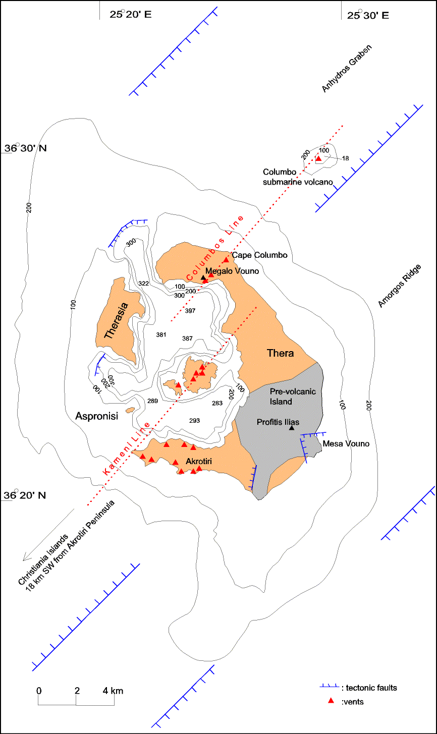
of single units following partial flooding in the late Miocene. The volcanic field of Santorini consists of
Santorini, the Christiania islands around 20 km to the southwest
and the submerged Columbus volcano 7 km to the northeast. It is
partly situated on a southwest - northeast trending tectonic
horst called the Amorgos Ridge. This fault block is visible in
seismic profiles. The northwestern half of the volcanic field
lies within the Anydros Graben. Most of the tectonic lines seen both on Santorini and on seismic profiles follow the general southwest-northeast trend. The most important one is named Kameni Line. It intersects the caldera and defines most of the known eruption centers. It aligns the Christiania islands, the Akrotiri peninsula and Palea and Nea Kameni. A parallel one, the Columbo line, perhaps identical with the Kameni line, passes through the centers of Megalo Vouno, the maar at Cape Columbo beach and the Columbo volcano. It seems that the rising magma has exploited existing deep-reaching tectonic fault zones. --- continue with: |

Copyright:
Before using text, graphics and photos of this page elsewhere please contact Tom Pfeiffer.
� Tom Pfeiffer, page last modified on 1 April 2004.